Also known as ...
Is it Safe to Head out the Gate?
For over two hundred years, the Golden Gate hid its existence from the Europeans transiting and exploring the coast of California by boat. First "missed" by Juan Rodriguez Cabrillo in November 1542, the Golden Gate was discovered accidentally in November of 1769 by a land expedition working it's way north along the San Francisco peninsula in an attempt to reach Point Reyes. Needless to say, the one to two mile wide expanse of water moving into and out of what would become known as San Francisco Bay halted the successful completion of the mission.
In 1846, John C Freemont coined the name we now know. In his memoirs he wrote
"To this Gate I gave the name of 'Chrysopylae', or 'Golden Gate'; for the same reasons that the harbor of Byzantium was called Chrysoceras, or Golden Horn." Freemont saw this as a "golden gate to trade with the orient." So, the name has nothing to do with the discovery of gold in California, or the famous bridge that spans its eastern end.
However, this is a sailing tip, not a history lesson or a linguistic exploration of the Greek word Chrysopylae, translated "Golden Gate." Instead, we will be looking at guidelines to follow while determining if and when it is safe to transit the Golden Gate, pass outside the line of demarcation, cross the San Francisco Bar, and sail the waters of the Gulf of the Farallones. It is important to remember, these are guidelines which do not take into consideration your level of skill, the skill of your crew, or the seaworthiness of your vessel, all things that MUST be taken into consideration when sailing anywhere, anytime.
 |
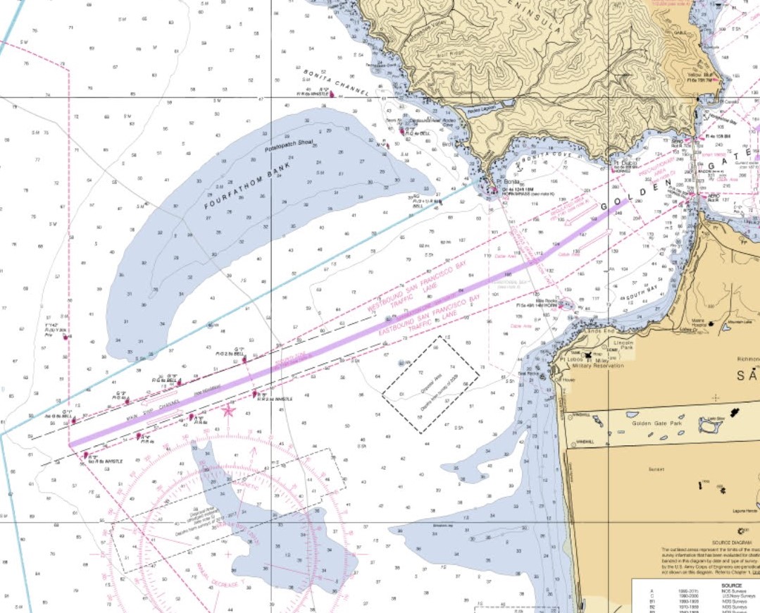
| Gulf of the Farallones - Chart 18645 |
Currents

Water from the Pacific Ocean flows into (floods) and out of (ebbs) on a cycle that repeats itself twice each day. In between each flood and ebb is a transition period referred to as slack water where there is relatively little movement of water. Step one of deciding if it is safe to sail outside the gate is determining the best time to transit the gate. To the untrained, the best time would seem to be during the ebb, so that you can ride the current out and get there quicker. Unfortunately, that is actually the worst time to go.
One of the first things someone notices when approaching the bridge from the bay is that the water begins to "feel" different. Less and less are you experiencing the wind driven waves and chop of the bay, and more and more you beginning to ride the swell coming in from the Pacific Ocean. During an ebb, water moving out of the bay at velocities that can exceed 6 knots runs into swell coming into the bay resulting in increases in size and frequency. A fact that is true of every river bar in the world. Throw in San Francisco's famous 25+ knot winds and things get really interesting.
Instead, I prefer transiting the gate, in either direction, on the slack before the flood. Second choice would be slack before the ebb, but get there a bit early. You don't want to get caught in transit during the ebb. The flood would be next (makes for a slow trip out or a quick trip in) with the ebb being last. If you must exit on an ebb, make it early in the morning before those breezes pick up. Better yet, wait a few hours and go out on the next slack. In the example shown, I would most likely leave Marina Bay about 10:30 to arrive at the bridge between 12:00 and 12:30.
Forecasts of the currents through the gate are found in tide books and online.
http://tbone.biol.sc.edu/tide/tideshow.cgi?site=San+Francisco+Bay+Entrance+(Golden+Gate),+California+Current
 |
| San Francisco Bar and Main Ship Channel |
Coast Pilot 7, Chapter 7, contains a wealth of information about transiting the gate and crossing the bar. The Coast Pilot Index if found at
https://nauticalcharts.noaa.gov/publications/coast-pilot/index.html
Click on California to bring up Coast Pilot 7. Unless otherwise indicated, all references to the Coast Pilot are from Coast Pilot 7, Chapter 7 (CP 7:7).
CP 7:7 Item 43, describes the San Francisco Bar as:
"a semicircular shoal with depths less than 36 feet, is formed by silt deposits carried to the ocean by the Sacramento and San Joaquin River systems. The bar extends from 3 miles south of Point Lobos to within 0.5 mile of Point Bonita off the southern coast of Marin Peninsula; the extreme outer part is about 5 miles west-southwest of San Francisco Bay entrance. Potatopatch Shoal the north part of the bar on Fourfathom Bank has depths from 24 to 28 feet."
The San Francisco Bar is the light blue areas of shallow water shown in the excerpt from the Entrance to San Francisco Bay chart above. It is approximately 8 miles from the bridge to the last buoy through the Main Ship Channel (G "1" Iso G 6s BELL). Expect it to take 2 hours (plus or minus) to transit the gate and cross the bar.
CP 7:7 Item 45 and 46 contain a warning:
Very dangerous conditions develop over the bar whenever large swells, generated by storms far out at sea, reach the coast. A natural condition called shoaling causes the large swells to be amplified and increase in height when they move over the shallow water shoals. This piling up of the water over the shoals is worsened during times when the tidal current is flowing out (ebbing) through the Golden Gate. Outbound tidal current is strongest about 4 hours after high water at the Golden Gate Bridge and attains a velocity in excess of 6 knots at times. The incoming large swells are met by outbound tidal current causing very rough and dangerous conditions over the bar. Steep waves to 20 or 25 feet have been reported in the area. Mariners should exercise extreme caution as the bar conditions may change considerably in a relatively short period of time.
The most dangerous part of the San Francisco Bar is considered to be Fourfathom Bank. Bonita Channel, between the shoal and the Marin coast, can also become very dangerous during large swell conditions. The safest part of the bar is the Main Ship Channel through the center of the bar. But even that area can be extremely dangerous when the tidal current is ebbing.
CP 7:7 Items 149 through 152 discuss currents in the area. In essence, the ebb goes straight out, and begins to fan as it goes across the bar. However, the main strength of the current runs parallel to the south edge of Potatopatch Shoal, and through the Main Ship channel. The flood runs straight in, with a slight set to the north shore. Heavy rips and overfalls can be found at each of the four corners of the Golden Gate (Lime Point at the north tower of the bridge, Fort Point and the south end of the bridge, Point Lobos near Mile Rocks, and Pt Bonita to the northwest) Overfalls at Point Bonita can extend 1/4 mile south into the strait. Eddys, rips, and overfalls can be extreme near the south tower of the bridge, and can cause even large ships to veer off course.

Once through the gate, crossing the bar through the Main Ship Channel is generally safest.
A forecast of conditions across the bar and through the Main Ship Channel is at:
https://marine.weather.gov/MapClick.php?zoneid=pzz545#.
Point 1 on safety out the gate: Time your exit to minimize the impact of dangerous currents. Generally, the slack before flood is best.
Channels across the San Francisco Bar
There are two channels across the San Francisco Bar.
- The Main Ship Channel
- Bonita Channel

If you are headed north, the buoyed Bonita Channel (about 1/3 mile wide), which proceeds north after passing Point Bonita, is approximately 1/4 mile off a steep, rocky lea shore and should only be used with fair weather and seas. It is often said, "If the fishing boats are not there, you should not be either." I have personally seen waves breaking across Bonita Channel when conditions in the Main Ship Channel were relatively comfortable.
If you are headed West or South (or if headed north in less than optimal conditions) use the Main Ship Channel. As mentioned earlier, forecast sea conditions for that day can be found online at
https://marine.weather.gov/MapClick.php?zoneid=pzz545#
The South Channel (aka; the one that isn't there!)
Several years ago, a popular cruising book author indicated there was an unmarked channel to the south running about .7 miles off shore, which could be used in fair weather. Unfortunately, the South Channel does not exist and its use continues nearly every year to claim vessels and lives. The mythical South Channel lies off a lea shore where the bottom slopes continuously from deep water to the shoreline. Just the conditions needed to create a surf break. A few years ago, a friend of mine who is a much better sailor than I am nearly lost his boat in this area. He was arriving from the South, a few miles offshore, when conditions (wind and waves) began pushing him to leaward while crossing the bar. Near the end of his bar crossing, he was convinced he would be driven ashore. Only his experience and skill saved him. The moral of the story ... stick to he Main Ship Channel.
Point 2 on safety out the gate: Use the Main Ship Channel in all but the most benign of conditions where Bonita Channel is an option, and under no circumstances use the mythical South Channel.
Conditions Outside the Bar
Conditions encountered outside the bar determine safety and comfort during a sail outside the gate.
Track forecasts for several days or a week prior to your planned trip. Look at weather forecasts, check for wind expectations, and track swell models. Several links will be provided below to help. Unfortunately, links change over time. My hope is this links will still be live when you read this, however, I can't guarantee it. However, I am sure there will be others to replace them, which with a little effort on your part can be found.
First a couple of definitions:
Combined Seas (generally referred to as
Seas)
The combination of wind waves and swell, without considering each component part separately. For example, today's forecast is for:
NW winds 15 to 25 kt with gusts up to 30 kt this morning. Wind waves 3 to 5 ft. W swell around 3 ft at 12 seconds. patchy fog this morning. This particular forecast doesn't mention the 1 foot secondary swell coming from SW at 16 seconds. I know it is there, so I will be adding it in.
Take the 5 ft from the 3 to 5 ft wind waves, add to it the 3 ft primary swell at 12 seconds, and the 1 ft secondary swell for a forecast combined seas of 9 feet at 12 seconds.
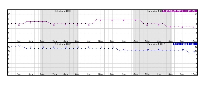
Significant Wave Height
The average wave height (trough to crest) of the highest third of the waves. Using a different internet source in the example below, you can see that today's forecast is for SWH of 6 ft at 12 seconds, increasing later today to 7 ft at 11 seconds.
Every sailor's skill and experience level is different, as are the levels of each member of your crew. These are two things that should always be primary in making the decision to proceed outside the gate. In my case, I use the follow criteria:
- Combined Seas greater than 12 feet; or
- Period less than 9 seconds; or
- Significant Wave Height equal to or greater than Primary Swell ( E.G. 9 ft at 9 seconds or less, or 11 ft at 11 seconds or less); or
- Wind (including gusts) greater than 33 knots; equals a decision not to go (No Go).
Looking at today's forecast ... Seas 9 feet, Period 9 seconds, Significant Wave Height 6 at 12 seconds, wind NW 15-25 gust to 30 ... everything looks OK. The gusts to 30 might be of some concern, however, it is within my personal guideline.
Forecasts are great, however, to be safe, I would also get current conditions by checking a report from the San Francisco Buoy
https://www.ndbc.noaa.gov/station_page.php?station=46026
 | Wind Direction (WDIR): | NW ( 320 deg true ) |
| Wind Speed (WSPD): | 13.6 kts |
| Wind Gust (GST): | 17.5 kts |
| Significant Wave Height (WVHT): | 5.6 ft |
| Swell Height (SwH): | 4.6 ft |
| Swell Period (SwP): | 7.7 sec |
and a swell model
http://cdip.ucsd.edu/?nav=recent&sub=nowcast&xitem=sf
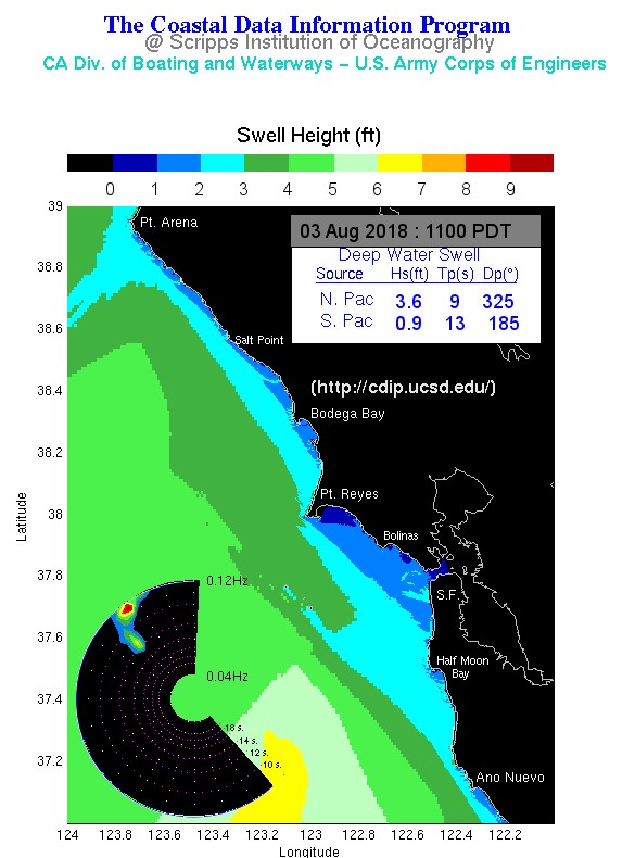
With the exception of period, everything at the buoy seems better than forecast, and I know from past experience that the period provided in the buoy report isn't just the primary swell I look at, it is more of an average of primary and secondary swells. It quite often is less than 9 seconds without bothering me.
Point 3 on safety out the gate: Seas 12 feet or less, Period 9 seconds or greater, SWH less than period length, winds less than 34 knots.
A final thought before I provide you with a list of reference links. During the planning stages of an Advanced Coastal Cruising class, the class is asked to track weather and sea state for several days before departure. No later than 3pm on the day before we leave the dock each person is to submit a Go/No Go recommendation for the following morning. It isn't unusual that the conditions result in a No Go recommendation. The requirements are pretty straight forward, so the vast majority of class members make the correct recommendation ... then, about half of them follow the No Go recommendation with a "but, I am willing to do it because I know there is an instructor on board."
My question is this ... knowing that these criteria have been established as an outside limit for safety, why would I (you can put your name here also) be willing to risk my life, the lives of my crew, and that of my vessel just to provide an experience that is outside safety guidelines. If you are a student in any sailing class, one of the things your instructor will be looking at while deciding to certify you is if you posses the mental consciousness required to be a Captain. Do you? Because, the role of Captain, is a very serious role that you take on.
Links
Here is a list of the links used above.